
The New Benchmark for Aerial Surveying
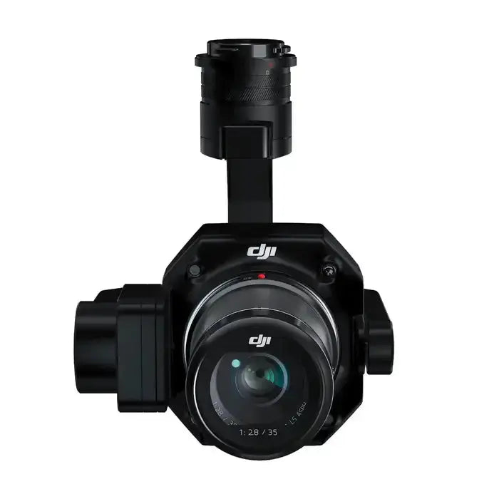
The DJI Zenmuse P1 is a next-generation full-frame photogrammetry camera payload designed specifically for aerial surveying and mapping. Integrating a 45 MP full-frame sensor with interchangeable fixed-focus lenses on a 3-axis stabilized gimbal, the P1 dramatically increases mission efficiency while delivering survey-grade accuracy.
With 3 cm horizontal and 5 cm vertical accuracy without GCPs, support for multiple fixed-focus lenses, and DJI’s TimeSync 2.0 system, the Zenmuse P1 is built for professional surveyors, engineers, and geospatial teams who demand reliable, high-precision data.
- Survey-grade accuracy without GCPs: approx. 3 cm (horizontal) / 5 cm (vertical)
- High-efficiency coverage: up to 3 km² per flight (mission-dependent)
- 45 MP full-frame sensor with 4.4 μm pixel size
- Global mechanical shutter: 1/2000 s shutter speed
- 3-axis stabilized gimbal with Smart Oblique Capture
- TimeSync 2.0: microsecond-level synchronization between modules
Key Features & Capabilities
Extraordinary Efficiency
The Zenmuse P1 is built to maximize coverage in the shortest possible time:
- 45 MP full-frame sensor with 4.4 μm pixel size.
- Low-noise, high-sensitivity imaging extends your usable daylight window.
- High capture rate: takes a photo every 0.7 seconds during flight.
- Up to 3 km² covered in a single flight (under ideal conditions).
- TimeSync 2.0 aligns the camera, flight controller, RTK module, and gimbal at the microsecond level.
Remarkable Accuracy
Equipped with a global mechanical shutter and advanced synchronization, the P1 delivers centimeter-level accuracy for demanding mapping and surveying missions.
- Global mechanical shutter: 1/2000 s shutter speed reduces rolling-shutter artifacts.
- Real-time position & orientation compensation for more precise georeferencing.
- Microsecond-level timing via TimeSync 2.0 ensures consistent, high-quality datasets.
Flexible Lens Options
Customize your payload for different mission types using interchangeable lenses:
- Supports 24 mm / 35 mm / 50 mm fixed-focus lenses.
- DJI DL mount for quick and secure lens changes.
- Optimized for 2D mapping, 3D modeling, and detailed inspection work.
Smart Workflows & Mission Modes
Smart Oblique Capture – Work Smart, Work Fast
Increase your daily productivity with Smart Oblique Capture. During oblique missions, the gimbal automatically rotates to capture images at multiple angles, ensuring optimal coverage while minimizing unnecessary photos.
- Cover up to 7.5 km² in a single workday (mission & environment dependent).
- Automatically captures only the images needed at the edges of the flight area.
- Improves post-processing efficiency by approximately 20–50%.
Smart Data Management
The Zenmuse P1 streamlines data handling to keep your workflows clean and auditable:
- Mission result files are automatically tagged with Mission Name and Mission Time.
- Centralized storage for photos, GNSS data, and TimeStamps.MRK files.
- Image metadata includes camera intrinsic/extrinsic parameters and RTK status.
Fieldwork Report
Verify data quality directly in the field. After landing, you can quickly review:
- Number of images captured.
- Position data and RTK status.
- Positioning accuracy indications.
Mission Modes for Any Scenario
The Zenmuse P1 supports multiple mission types, making it suitable for a wide variety of deliverables:
- 2D Orthomosaic Missions: Generate high-accuracy orthophotos without GCPs, ideal for medium and large areas.
- 3D Oblique Missions: Capture multi-angle datasets for urban, structural, and facade modeling.
- Detailed Modeling Missions: Create dense, high-resolution 3D reconstructions of critical assets and structures.
- Real-time Mapping Missions: Produce quick situational maps for time-sensitive operations.
Application Scenarios
Topographic Mapping
- Capture data that meets 1:500 scale accuracy requirements without GCPs (under appropriate conditions).
- Ideal for land surveying, cadastral mapping, and terrain modeling.
Urban Planning & 3D Modeling
- Generate high-fidelity 3D city models for planning and design.
- Support volumetric measurements, change detection, and infrastructure analysis.
Infrastructure & Asset Inspection
- Produce high-resolution, geo-accurate models of roads, bridges, and industrial facilities.
- Enable precise measurements and condition assessments directly from your photogrammetry outputs.
Disaster Response & Documentation
- Rapidly map large affected areas with centimeter-level accuracy.
- Support decision-making, insurance documentation, and reconstruction planning.
In The Box
- 1 × Zenmuse P1 Gimbal and Camera
- 1 × 16 GB microSD Card
- 1 × 128 GB SD Card
- 1 × Storage Case
- 1 × Camera Body Cap
- 1 × Lens Rear Cap
- 1 × Lens Cleaning Cloth
- 1 × Lens Cap
- 1 × DJI DL 35 mm Lens
- 1 × DJI Terra Activation Code